Climate tipping points are thresholds in the Earth’s climate system. When passed, this system experiences abrupt and typically irreversible changes. Over the past decade, there has been a rapid evolution in research around these tipping points, and we now know that some could be crossed over the coming decades, dramatically worsening an already dangerous climate situation.
With tipping points, small, gradual changes—global temperature increases, for example—can result in strong, fast, and extreme responses in the system. The effects, which can range from temperature increases, changes in precipitation patterns, increased storminess, flooding, and drought, go above and beyond those already predicted in climate change scenarios.
These changes will wreck the lives of countless millions of people, especially in the most deprived areas of the world. Livelihoods will vanish, homes will be rendered uninhabitable, communities will be sundered, and people will die. This growing threat has led to calls for immediate political action to reduce global greenhouse gas emissions and help the most vulnerable prepare for a more hostile climate.
In this blog series, we take a look at four of the most treacherous tipping points: the Amazon rainforest, Coral Reefs, and the West Antarctic Ice Sheet. We also provide an overview of their physical nature and their impact on human security, including the important issue of loss and damage, a topic which became a major discussion point at COP27.
Back in 2019, a research team led by scientists at the University of New South Wales published results stating that mass melting of the West Antarctic Ice Sheet (WAIS), driven by warmer ocean temperatures, was a major cause of extreme sea level rise between 129,000-116,000 years ago. The study found that the melting of the WAIS caused a sea level rise of more than three metres, and that it took less than 2°C of ocean warming to make it happen. It is likely that a large part of the WAIS disappeared at that time because it had melted away, flowing into the adjacent ocean.
Further geological evidence demonstrates that such a collapse of the WAIS has occurred repeatedly in the past. An abrupt retreat occurred during the early deglaciation from the last ice age, around 12,000 years ago, and is well recorded in data on the eastern Ross Sea continental shelf, where an ice shelf breakup caused accelerated ice loss.
Sure, the last mass melting of the WAIS occurred many thousands of years ago, the world survived, and the ice sheet regenerated given enough time, some might say. However, there weren’t hundreds of millions of people living in coastal metropolises during those times. Today the risk of sea level rise from ice sheet loss is serious business at international climate conferences like COP27—recently held in Egypt—precisely because of the risk to human civilisation along coastlines the world over. According to the IPCC, ‘Beyond 2050, uncertainty in climate change induced sea level rise increases substantially due to uncertainties in emission scenarios and the associated climate changes, and the response of the Antarctic ice sheet in a warmer world.’
Data from the past on ice sheet changes is robust and has obvious implications for the near future under continuously changing anthropogenic climate conditions.
What is the WAIS and how important is it?
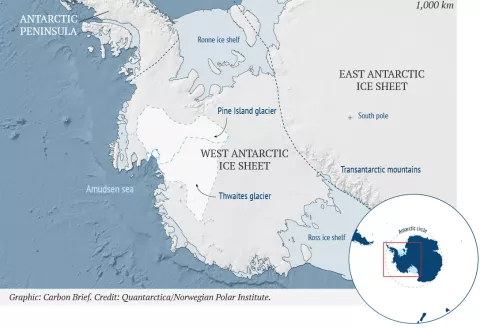
The WAIS is a portion of the continental ice sheet on Antarctica classified as a marine based ice-sheet, meaning its base lies below sea level. Just like other ice sheets—the largest on Earth being the East Antarctic Ice Sheet—the WAIS acts as a gigantic water storage, keeping sea levels static and coastlines intact. Between its east and west ice sheets, and its peninsula, Antarctica boasts enough ice to raise global sea levels by almost 60 metres. The WAIS accounts for a relatively small portion of this—just over 3 metres—but is considered to be at risk because of its precarious position. A collapse of the entire WAIS would result in a global mean sea level rise of approximately 3.3 metres, over a timescale of centuries to millennia. This would result in the flooding of coastal areas and cities where hundreds of millions of people live.
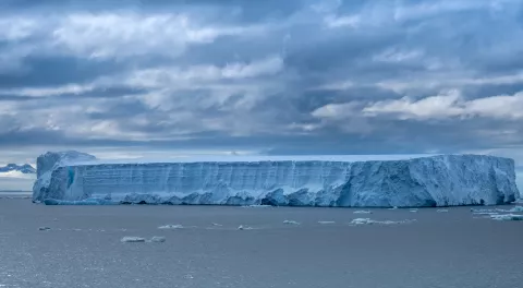
The ice sheet is so massive that it causes the underlying bedrock to sink and the ice to deform and thereafter flow under its own weight. When the flowing ice reaches the coast, it either calves—meaning giant chunks break off into icebergs—or continues to flow outward onto the water, mostly into the Amundsen sea. The result is a large, floating ice shelf which operates essentially as a component of the continent. As mentioned, large parts of the WAIS sit on a bed which is below sea level. This means it is extremely vulnerable to ocean warming, and that a small retreat could in theory destabilise the entire ice sheet, leading to relatively rapid disintegration.
We now know that the WAIS is losing ice at an increasing rate and that its stability has begun to deteriorate. Ice is being lost into the adjacent Amundsen Sea via the three major glaciers in the region: Pine Island Glacier, Thwaites Glacier, and Smith Glacier. Data reveals that these three glaciers are losing more ice than is being replaced by snowfall. Now a major concern is the potential future loss of the ice shelves, because it is the shelves which help to support the glaciers which they are holding back.
Satellite measurements by the European Space Agency’s CryoSat-2 revealed that the WAIS is losing more than 150 billion tonnes of ice annually (enough to raise global sea levels by as much as 0.45 mm each year). The loss is especially pronounced in the areas where the floating ice shelf meets the part resting on bedrock, and hence affects the entire ice stability and ice flow rates.
Tipping point science and threat
The WAIS is suggested as a climate tipping point because increasing ocean surface temperatures in the region increase its risk to become unstable. Elevated temperatures cause sub-surface melting and marine ice-sheet instability. A lot of research suggests that a tipping point has already been reached, with a recent study indicating that the threshold for irreversible loss of the WAIS is likely at or beyond 1.5°C above pre-industrial levels, maybe even as low as 1°C—where we are currently at.
According to Prof. Timothy Lenton, when interviewed for Germanwatch, ‘there is a fairly large uncertainty around how quickly the WAIS would disappear, and while the threshold appears to be 1.5°C–2°C, it is unclear whether a complete collapse would take centuries or millennia.’ Another threshold may lie between 2°C and 2.7°C, according to another study which suggests that reaching this level of global temperature rise could trigger the activation of several larger systems, such as the Ross and Ronne-Filchner drainage basins. If affected, these areas could induce further melting and subsequent sea level rise.
Furthermore, because of changes to the gravitational mass of the ice sheet itself, so-called eustatic sea level rise is not uniformly distributed across coastal regions worldwide. With regards to the impact on human society, it is therefore important to note that the sea level rise caused by the melting of the WAIS will have a more far-reaching impact on some regions than on others.
Socioeconomic impacts, loss and damage, and human security
Vulnerability
It is easier to grasp the impact of sea level rise on coastal peoples if we first assess their vulnerability. Globally, 410 million people and 4,107 thousand square kilometres of land are exposed to a 5m sea level rise—and coastal populations are rising. As stated above, geographic vulnerability varies greatly: some Small Island Developing States (SIDS) are more low-lying than others. Economic capacity also varies greatly between, say, coasts in the Netherlands and those in Bangladesh, and with it the level of insecurity. Vulnerability, therefore, is very uneven.
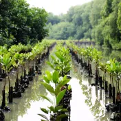
Shared geographic features make SIDS especially vulnerable. SIDS are a group of 57 small island countries, home to over 62 million people. They generally have high population densities and growth rates. Many suffer from unsustainable human activities, including the destruction of coastal protections like corals and mangrove forests. Above all, populations and economic activity are concentrated on the coasts. This puts people as well as roads, schools, houses, and factories, within the inundation danger zone.
In the Seychelles, about 80% of the infrastructure and population is to be found on the coast. In Dominica, it is as high as 90%. Coastal plains are attractive places to live and work. Moreover, higher-lying areas are more susceptible to storms and hurricanes. Much of the populated land is below sea level, reclaimed to accommodate population growth. In general, about 22 million people in the Caribbean live on land at risk of inundation.
For the world’s 136 port megacities, a 0.5m rise in sea level will expose up to US$28 billion in assets. Any damage to ports weakens economic security, especially in SIDS. Barbados, for example, depends on the global economy for imports of food, fuel, and construction material.
Subsistence agriculture is thus essential, especially in low-lying atoll countries where food security suffers from water shortages. Freshwater is highly sensitive to sea level changes. Also threatened by climate change are the other essential industries: fisheries and tourism. The latter, in particular, provide the investment and tax revenues that are crucial for enhancing welfare. Without this, the social safety net vanishes.
Funds for unilateral mitigation or adaptation efforts are sparse. So is capacity. A lack of educational opportunities means there is a dearth of qualified people for adaptation planning and implementation. In sum then, many SIDS residents are at great risk of losing their homes or even lives, more are economically insecure, working in jobs to which sea level rise poses a grave threat, and most live in communities without the resources to ameliorate much of this insecurity. While coastal peoples everywhere are vulnerable to rising sea levels, SIDS peoples are especially so. Let us thus turn to the probable impacts they face.
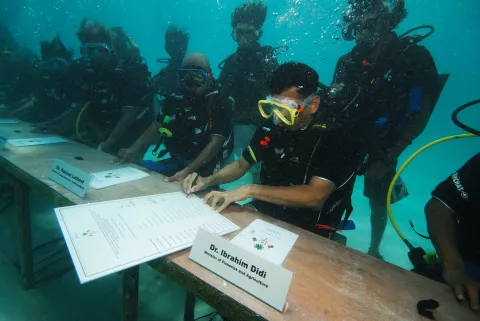
Maldives Minister of Fisheries and Agriculture Dr. Ibrahim Didi signs decree under water to bring attention to the threat of sea level rise for the Maldives (Mohamed Seeneen / Climate Visuals).
General costs
The costs of sea level rise fall now into the category of Loss and Damage, which is a measure that takes in both the money spent to avoid climate impacts and the cost of the impacts that won’t be avoided. The overall global cost ranges, depending on the study, from less than 1% of global annual GDP to as much as 5% by 2100. The costs depend on how warm the world gets and how successfully we adapt, but also on the methods used by the researchers. The costliest impacts are permanent inundation, flooding, and especially the relocation of human populations.
For specific costs, we need to look to the past. The loss and damage caused by tropical cyclone Dorian, in which sea level rise had a hand, cost The Bahamas 1% of GDP, US$2.5 billion in damages, US$717 million in losses, 30,000 people impacted, 282 missing, and 67 fatalities. The cumulative total damages caused by tropical cyclones from 1990 to 2013 amounted to over 10% of cumulative GDP for nine SIDS. With sea level rise, extreme weather events like this will become more frequent. Overall, Pacific SIDS have the highest per capita disaster risk globally, and we know that this risk is going to rise substantially. Let us try to understand what this means more concretely.
Retreat and relocation
We know that while 85% of the world’s exposed and populated coastlines are currently protected, with sea level rise, this will drop to 50% by as early as 2030, adding greatly to the insecurity of millions of people on the coasts. Many coasts will be judged too expensive to defend. This means countless people must leave their homes and communities against their will.
A disproportionate number of them will come from SIDS. Up to 5.7% of the total SIDS population will be impacted by floods by 2100, but some SIDS will suffer worse than others. With a 1-metre sea level rise, the Maldives will disappear entirely. Grenada would lose 60% of its beaches. Tuvalu has explored the possibility of buying land in a nearby country to mitigate this existential insecurity, but there are few examples of successful relocations like this. The Gilbertese resettlement in the Solomon Islands was replete with tensions. Moreover, it is far harder for women to relocate than it is for men, due to a range of gender norms and structures. Maldivian women, for example, are discouraged by social stigma from pursuing a range of occupations, which leaves them less employable. However, there may be little choice. With resettlement, SIDS peoples will face issues like homelessness, unemployment, and the dismantling of families and communities.
SIDS are not the whole story, however. Large scale displacement will occur in many other places. Even where coasts can be protected, fear of dangerous weather events will cause migration. Many will fear incompetent adaptation and in many cases, they will be right to do so. Mismanaged flood defences will lead to greater insecurity for people living along the coast. On top of the myriad human security issues exacerbated by such moves, the costs involved must necessarily detract from welfare spending elsewhere.
Water and food security
For those who are fortunate enough to remain in their homes, life will get considerably more parlous. A big reason why is water. In coastal zones, freshwater is less well insulated from salt water. Moreover, many SIDS rely on a single water source. With sea level rise, saltwater intrusion becomes much more likely. This raises the prospect of freshwater becoming a scarce and possibly unreliable commodity for many communities.
This is compounded by the fact that in much of the Pacific, crop agriculture is generally found on the coasts. Few edible plant species tolerate salt, and with soils deteriorating under the effect of salinisation, even the fairly tolerant coconut tree will eventually die. Crop agriculture will suffer further from the impact biodiversity loss will have on ecosystem functioning. Tie this to land lost through flooding and inundation, and a major increase in food insecurity is likely. The extent depends on adaptation, but food prices can be expected to rise, alongside an increased dependence on imports. Even fish stocks, a key staple, will struggle to replenish themselves as sea level rise and warming destroy their mangrove and sea grass nurseries.
Non-economic loss and damage
To get a true sense of the insecurity tipping points herald, we should count threats to identity. With a 3°C temperature increase, sea level rise will affect nearly 20% of UNESCO world heritage sites.
The destruction of spiritual places, protected areas, and heritage sites will undermine identity and damage community cohesion. In the case of Monkey River Village in Belize, coastal erosion, exacerbated by sea level rise, is threatening the community’s cemetery. Residents place significant spiritual and emotional value on the cemetery, which serves important community functions.
We know from research that community solidarity and cohesion, linked to place-based identity, is being undermined by relocations linked to sea level rise. This is known to weaken adaptive capacity. In other words, identity security is tied inextricably to other forms of security. No wonder, then, that the mental health of Tuvaluans is declining steeply.
Adaptation
The impacts of crossing the WAIS tipping point depend on how successfully the world adapts. Global inequality is a major factor. In the Netherlands, adaptation costs are estimated at 3-4% of GDP. Conversely, a 1 metre rise in sea level may cost Jamaica 19% of GDP. This is clearly unaffordable. In order to protect Malé, the capital of the Maldives, from flooding, a system of protective barriers was built at a cost of US$4,000 per metre. This was largely financed by the Government of Japan. Similar efforts are needed on a far bigger scale if the most vulnerable are to be protected.
With their extreme vulnerability and accordingly ruinous costs, thorough adaptation efforts are beyond the means of most SIDS. According to the UN, most have not even been able to undertake the impact assessments necessary for successful adaptation. Even if aid is forthcoming, it will likely be diverted from other key socio-economic priorities, transferring the insecurity elsewhere.
Although figures vary depending on the study consulted (for example, 1, 2), it is agreed that strenuous adaptation efforts will dramatically reduce the loss and damage that sea level rise will otherwise visit upon coastal peoples. Building on existing cultural ties and practices has been shown to greatly improve the chances of success. That, at least, is something positive upon which to begin adapting.
Open research questions
Though the WAIS is among the better researched tipping points, there is still a lot of data that ought to be gathered. We don’t really know enough about how successful various adaptation efforts will be, nor indeed what limits to adaptation there might be. We also do not have enough data from SIDS to thoroughly measure sea level rise impacts. Too often we must rely on very abstract global estimates that themselves may be quite wrong because they are not well-enough informed by country-level data. This also means that the variability in vulnerability is under-researched.
Although over the past few years, some efforts have been made to focus on non-economic loss and damage, much more needs to be done. By not integrating non-economic losses into our calculations for the Social Cost of Carbon, we are almost certainly underrating the harms the passing of tipping points will visit upon coastal peoples.
Dr. Conor Purcell is a climate researcher and award winning science writer. Dr. Michael Keary is a political scientist, specialising in environmental politics and political theory. The authors are the co-founders of NovaAura Research, helping NGOs and government bodies understand future climate projections and environmental policy.